Wamkelekile, Welkom
Drones used to assess UCT fire damage
28 April 2021 | Story Nadia Krige. Photo UAV Industries. Read time 6 min.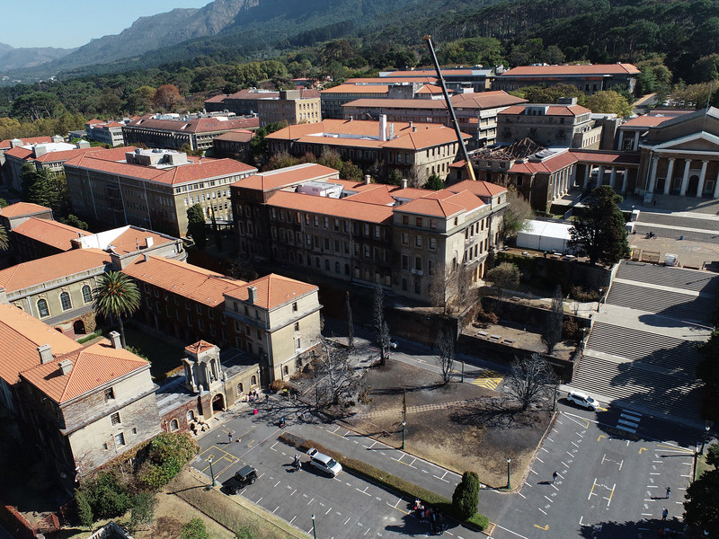
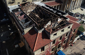
State-of-the-art drone technology is being employed at the University of Cape Town (UCT) to assess the extent of damage caused by the wildfire that raged through parts of upper and middle campus on Sunday, 18 April.
UAV Industries, one of South Africa’s leading legal drone operators, has been contracted to inspect the overall fire damage and provide essential information to determine the total value of the loss. UCT alumnus Richard von Seidel is the chairperson and director of the company.
“There are a number of parties who are interested in this data,” said Dr Walter Uys, the co-founder –with Dr Sumarie Roodt – of the Tech4Good Lab, situated in UCT’s School of Information Technology (IT). “The insurers need to do an assessment of the damage, the architects need to know what steps to follow in appropriately securing and repairing the affected sites and then, of course, the whole UCT community.”
A commercial aeroplane pilot who has been flying and researching unmanned aerial vehicles (UAVs) for more than two years, Dr Uys leads the Drones4Good research lab at UCT and has worked closely with UAV Industries on a number of projects.
“It was agreed that capturing drone footage would be the most feasible option, especially considering the height of the buildings and the steep slope.”
It was, in fact, one of his students – who was severely affected by the fire – who sparked the idea of using drones to assess the damage.
“During the event, he sent me pictures of the flames approaching his home and we started talking about how drones could actually be used to help manage fires by identifying heat spots with thermal imaging,” said Uys.
This inspired him to contact the team at UAV Industries, who were immediately on board to assist in the assessment of damage for insurance purposes. The company is one of the few drone operators in South Africa that has the advanced equipment and Beyond Visual Line of Sight certification required for this type of assessment.
“While it was devastating for South Africans – students and non-students alike – to watch our beloved university burn, we are very proud to be part of the team that is assisting in its rebuild,” said Von Seidel.
A game changer
Uys and his team put together a proposal for UCT’s chief operating officer, Dr Reno Morar, who then forwarded the request to the director of programme management and properties at UCT, Greg Skeen. In the meantime, Braam Botha, the operations executive at UAV Industries, liaised with the university’s insurers to establish next steps.
“We got everyone together on campus and it was agreed that capturing drone footage would be the most feasible option, especially considering the height of the buildings and the steep slope,” said Uys.
The alternative would be traditional survey methods that require additional infrastructure, such as scaffolding and cranes, as well as greater human intervention, which poses an increased risk to personnel.
Furthermore, compared to the precision and accuracy drones are capable of achieving, the alternative data would be limited in its detail and gathering it would also take longer to complete, thereby delaying repairs.
Botha said that drones have become a real game changer in the survey and mapping industries, especially when it comes to compiling data for insurance claims.
“Without drone technology to assist with the insurance claim process,” he said, “the full size and complexity of the loss would be much more difficult, timely and costly to measure.”
Beyond aerial photography
While drones are mostly associated with breathtaking scenes filmed from a bird’s-eye view, their uses are far more varied than merely capturing aerial imagery and footage.
To assess the damage at UCT, Botha and his team have used a range of different drones and cameras, as well as specialised software to analyse the data.
This includes a 3D survey of all damaged structures using high definition (HD) and thermal photogrammetry; 3D mapping of the inside of damaged buildings using light detection and ranging (LiDAR) sensors; and a full site survey of upper campus and parts of middle and lower campus to document damage to roofs and track how the fire spread.
With LiDAR technology, the team is able to map interiors and exteriors to look for defects beneath the surface. This may include steel structures that have expanded, causing minor cracking, severe cracking or complete delamination of plaster.
“YouTube videos and Facebook photos taken from ground level simply don’t give you an idea of the entire impact.”
“With the data captured by drone,” said Botha, “we are able to create 3D models of the existing structures and convert these into computer-aided design (CAD) models to indicate which parts of the buildings can remain and what resources will be needed to rebuild or restructure – all to an extremely high level of accuracy.”
These 3D models can then be converted into centimetre-accurate 3D architectural models to assist with building redesigns and repairs.
Uys said that an additional benefit of conducting the drone surveys was setting people’s minds at ease about the extent of the damage on campus, especially in the wake of alarmist messages doing the rounds on social media.
“It’s really sad that we’ve lost two buildings and had some damage to others, but the good thing is that most of UCT’s buildings are intact.
“YouTube videos and Facebook photos taken from ground level simply don’t give you an idea of the entire impact.”
Results
Once all the data has been gathered, it should take about a week to process. After this, it will be signed off by a certified engineer with a suggested repair methodology.
“Despite the ongoing challenges faced by the drone industry in South Africa, there is still so much potential for drone technology to help businesses of all shapes and sizes increase their operational efficiency and excellence,” said Von Seidel.
 This work is licensed under a Creative Commons Attribution-NoDerivatives 4.0 International License.
Please view the republishing articles page for more information.