Wamkelekile, Welkom
Protecting Petra: UCT team maps 'wonder of the world'
12 November 2012The Zamani Research Group of UCT's Geomatics Department is in Jordan, partnering with UNESCO and other international institutions, to digitally survey and map the rock city of Petra, the fabled 'rose-red city, half as old as time'. Their work will underpin a sustainable stability plan for the geologically fragile World Heritage Site.
 |
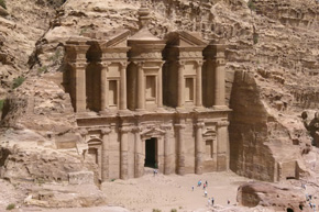 |
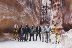
| Emer Prof Heinz Rüther (far right) and his team at work with their scanners in the Siq that is the entrance to the fabled city of Petra, Jordan, the rock-cut city noted also for its water conduit system. Oxidisation of the rock creates marbleised colours. Their Jordanian assistants are Tawfick (far left) and Jamal (third from left). The UCT team is Roshan Bhurta (second from left), and Stephen Wessels and Ralph Schroeder (second and third from right). | Mighty architects: The Nabateans carved their tombs and edifices into the multi-hued rocks of Petra, which once occupied an important position on the spice and incense routes from east Asia and Arabia. |
It's listed by the Smithsonian Magazine as one of the 28 places to see before you die.
Located halfway between the Dead Sea and the Gulf of Aqaba in Jordan, its lofty tombs and monuments carved into the oxidised sandstone mountains, the prehistoric city of Petra is an architectural and cultural oasis at the foot of the gorge- and tunnel-riddled Mount Hor, or Jabal Haroon, the burial place of Prophet Aaron.
Once a thriving centre of trade, Petra was the capital city of the Nabateans, a nomadic people whose empire rose to its peak between 400 BC and AD 100. But the city was lost to the Western World for seventeen centuries until in 1812, Swiss traveller Ludwig Burckhardt gained entry, disguised as a Bedouin.
In 1985 UNESCO declared Petra a World Heritage Site. Now it attracts up to 5,000 tourists a day in high season. But its sustainability is being threatened by earthquakes and floods - and by its own geological fabric: the increasingly unstable 500 million-year-old iron-red cliffs.
Part of its mystique lies in its inaccessibility. Entrance to Petra is through the Siq (meaning 'crack'), a narrow slot canyon up to 120m high and 1.2km long that traces the Wadi Musa or Moses River. From between the vertiginous cliffs the Siq deposits you directly in front of the Treasury (Al Khazneh).
If you're a Harrison Ford fan you'll remember it well. There's that scene in Indiana Jones and the Last Crusade where Jones junior (Ford) and senior (Sean Connery) rush from the Siq into the labyrinths of the Treasury in search of the Holy Grail.
In fact, the Treasury is only a façade with a small hall, once used as a royal tomb. But if Hollywood is less interested in detail and authenticity, not so the Zamani Research Group at UCT's School of Architecture, Planning and Geomatics.
Led by veteran Emeritus Professor Heinz Rüther, the team of Ralph Schroeder, Roshan Bhurtha and Stephen Wessels is partnering with UNESCO, the Jordanian Department of Antiquities, and ISPRA (the Italian Institute for Environmental Protection and Research) on a million-US-dollar, 30-month contract to produce a stability plan using sophisticated surveying and laser-scanning mapping techniques.
It's something of a coup for the team.
They're not just consultants on the project; they're partners, says Rüther. And they come with a reputation, highly respected for their heritage documentation skills. They employ laser scanning, conventional surveys, GPS surveys and photogrammetry to produce Geographic Information Systems (GIS), 3D models and interactive panorama tours of heritage sites.
They've covered 40 sites in 13 countries and have digitally mapped many of Africa's famous heritage landmarks, from Fort San Sebastian on Ilha de Mozambique, and the fabled mud Grand Mosque in Djenné, Mali, to the rock-cut churches of Lalibela in Ethiopia, and the complete Valley of the Queens in Luxor, Egypt. In the past two years Rüther has published five papers, and last month delivered a workshop on their work to the Chinese Academy of Science in Beijing.
Petra offers a different challenge. Here the plan is also to sustain the site by identifying and monitoring unstable slopes and sections at risk in the Siq.
"Much of the city has been destroyed because of natural weathering and earthquakes," says Rüther. "Using GPS and photogrammetry, we are mapping the walls of the Siq to look for cracks and fissures and anything that could assist to create a risk management plan to maintain slope stability."
It's their second visit to Petra following a 2011 Mellon-funded trip to conduct a 3D laser scan of the Siq's lower section and the Royal Tombs, including the Urn Tomb.
There are a number of components to the current operation. They will contribute to the design of the Siq Monitoring System, develop a GIS for the entire Petra National Park Area, and create 3D computer models of the principal temples and tombs of Wadi Araba and Wadi Farasa, including the Treasury, Royal Tombs, Urn Tomb, Monastery and the Amphitheatre.
All this will be combined in an interactive virtual tour of the site. Honours students from the Department of Computer Science are contributing to the virtual tour.
The partnership requires that they share their skills with their Jordanian counterparts, which they do by including local professionals and students in their field campaigns.
There is richness in working with the Petra community, adds Rüther. Over 20,000 photographs on his database show the arid but dramatic landscape they're working with - as well as some of the personal vignettes. To protect the site the Bdoul Bedouins, inhabitants of the site when Burckhardt visited Petra, were relocated from the Wadi Araba valley to a new village overlooking Petra. The Zamani team works closely with the Bdoul, relying on their knowledge of the rugged and very difficult mountain terrain surrounding the site - as well as on their hospitality.
Rüther talks of the special moments when they're invited for 'Bedouin tea' by Bdoul who still live in tombs and tents in the more remote areas of the Petra Park, or when listening to the stories of camel and donkey guides who show a keen interest in the team's work during lulls in the flow of tourists.
In one photograph there's a Bedouin guide who's a dead-ringer for Johnny Depp in Pirates of the Caribbean. But he plies his trade on the ship of the desert - leading camel tours through this ancient city.
 This work is licensed under a Creative Commons Attribution-NoDerivatives 4.0 International License.
Please view the republishing articles page for more information.