Wamkelekile, Welkom
Map pinpoints access routes for wheelchairs
25 May 2009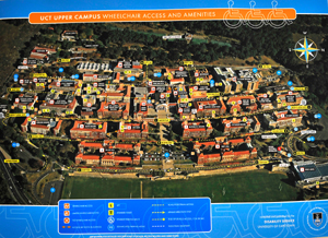
A new map launched by the Disability Service on 13 May will make access to the upper campus and its facilities easier for people in wheelchairs.
The map shows wheelchair routes to buildings and plots easy-access paths to amenities and roads. It also identifies the 52 parking bays for disabled drivers.
Of particular value are the notes on access limitations and the cautionary tips for wheelchair users, for example, alerting them to 'hotspots' on campus where there are no pavements and where there is heavy vehicular traffic.
The map is the result of careful planning and numerous recces of the upper campus by Edwina Konghot (barrier-free access co-ordinator) and her colleagues.
They built the new map on the existing one of upper campus, noting new buildings, doors, ramps and lifts.
"We discovered lifts and disabled toilets in the Chancellor Oppenheimer Library that we didn't know existed," said Konghot.
There were other surprises, like the door marked Disabled Toilet that turned out to be a front for a broom cupboard!
Given 18 months to complete the map, Konghot and her colleagues wrapped up the project in just eight months.
Next up is a map of the health sciences campus.
The time allocation is two years, taking into account the convoluted nature of this campus and its interconnected buildings and facilities.
But Konghot, eyeing her walking shoes, hopes to complete the task in half the time.
(Copies of the upper campus map are available free from the Disability Service. To order, please phone 021 650 2427.)
 This work is licensed under a Creative Commons Attribution-NoDerivatives 4.0 International License.
Please view the republishing articles page for more information.